Maritime and Port Sector
The channel bed and the quay, measured in the same reference frame
We survey access channels, basins and maneuvering areas with multibeam bathymetry from uncrewed surface vessels (USV), and quays, breakwaters and yards with 3D laser scanning. You receive the seabed model, the topo-hydrographic plans and the As-Built of the works.
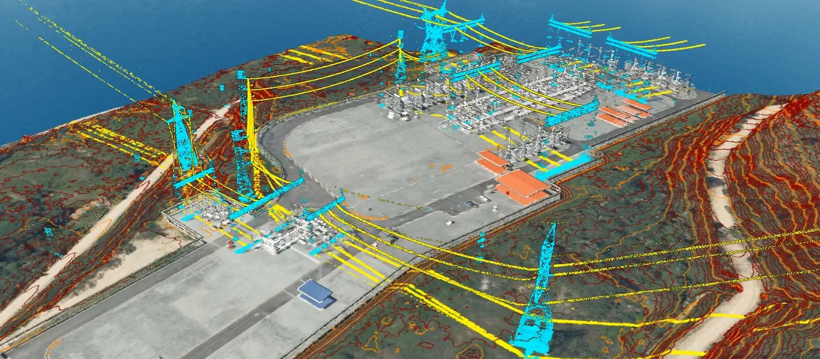
At a terminal, water and land are usually surveyed separately: the bathymetry is referred to chart datum and the topography to the geodetic network. If nobody links the two, the depth alongside the quay and the drawings of the works do not agree. So before we measure, we tie bathymetry, topography and scanning to one control network.
On that network we cover the whole terminal: bathymetry before and after dredging, 3D scans of quays, cranes and warehouses, stockpile volumes, and monitoring of the shoreline and the harbor protection works.
Experience and results
- 5M+
- hectares surveyed
- 1200+
- projects delivered
- 200+
- clients
Where we work in the maritime and port sector
Port terminals
Full terminal survey, asset inventory and As-Built models.
Quays and berths
3D laser scanning, dimensional control and deformation monitoring of the structure.
Access channels and basins
Multibeam bathymetry, operating draft checks and dredging verification.
Breakwaters and harbor protection works
3D models of the rock armor, volume calculations and scour tracking.
Yards, warehouses and terminal roads
Mobile mapping, layout optimization and geospatial inventory.
Shoreline and coastal defenses
Shoreline surveys, and tracking of erosion and sedimentation.
Four business lines, from planning to monitoring
Plan, design, build, operate and monitor. The same four lines in every sector, with the activities and deliverables that sector needs.
Levantamiento, Cartografía y Modelado
Survey, Mapping & Modeling
“Multibeam bathymetry on the water, LiDAR and 3D scanning on land”
- Airborne, terrestrial, mobile and drone LiDAR over terminals, yards and coastal strips
- Surveying, geodesy, GNSS networks and precise leveling
- Digital photogrammetry, orthophotos and digital terrain (DTM) and surface (DSM) models
- Hydrographic surveys and multibeam bathymetry of access channels, basins and quays
- Mobile mapping and 3D laser scanning of quays, cranes, warehouses and terminal roads
- Digital mapping and modeling of port corridors and the shoreline
- 3D modeling, digital twins and As-Built BIM models of quays and harbor protection works
- Geospatial inventory of port infrastructure
- Port cadastre, property management and delineation of the coastal strip
Deliverables
Classified point cloud · DTM/DSM · Multibeam bathymetry and seabed models · High-resolution orthophoto · Topo-hydrographic plans · 3D models · As-Built BIM · Digital inventory of port assets
Control y Aseguramiento de Calidad
Quality Control & Assurance
“We check design depths and dredging volumes”
- Geodetic control and setting out of quays, breakwaters, dredging and harbor protection works
- Geometric verification and dimensional control with surveying, LiDAR and 3D laser scanning
- Independent audit of topographic, bathymetric, LiDAR and photogrammetric surveys
- Geospatial QA/QC to international standards (IHO S-44, ISO 19157, ASPRS)
- Validation and integration of BIM models, GIS data and point clouds for engineering and construction
- As-Built control and asset verification during construction, operation and maintenance
- Calculation and verification of dredging, fill and stockpile volumes
Deliverables
Geodetic control report · Geometric verification record · As-Built report · QA/QC report (IHO S-44 / ISO 19157 / ASPRS) · Setting-out drawings · Independent audit report
Monitoreo de Infraestructura Marítima y Gestión de Riesgos
Ground & Marine Infrastructure Monitoring
“We pinpoint where the channel is silting up and where the structure is being scoured”
- Geotechnical instrumentation of quays, breakwaters, hydraulic fills and coastal slopes
- Geodetic and topographic monitoring of deformation, settlement and displacement
- Multitemporal monitoring with LiDAR, drones, GNSS and InSAR for early change detection
- Repeat bathymetric surveys to track sedimentation, scour and coastal erosion
- Operating draft checks and verification of design depths
- Integration of instrumentation, GIS and spatial analysis for risk prevention
- Assessment of how critical infrastructure performs during operation
Deliverables
Periodic deformation reports · Multitemporal change maps · Comparative bathymetry and sedimentation rates · Geotechnical performance reports · Threshold-based technical alerts · Risk management reports
Soluciones Digitales e Inteligencia Artificial
Digital Solutions & Artificial Intelligence
“A digital twin of the terminal to plan yards, dredging and maintenance”
- Digital twins of port terminals and marine works, updated with each monitoring campaign
- BIM + GIS integration to manage port assets and infrastructure in one place
- Yard layout optimization and dredging planning with geospatial analysis and AI
- Geospatial dashboards to track operating and draft indicators
- 3D virtual tours for inspection, planning and remote collaboration
- Predictive analytics and AI to anticipate sedimentation, operating risks and asset failures
Deliverables
Digital twin of the port terminal · Integrated BIM + GIS platform · Geospatial dashboard · Predictive models and automated reports · 3D virtual tours
Who we work for
- Port authority
- Maritime authority
- Consulting and engineering firms
- EPC contractors
- Port operators
- Terminal concessionaires
- Banks and investors
- Hydrographers and GIS specialists
Brochure
Download the sector brochure
Leave us your details and download the sector brochure, with our lines of work, activities and deliverables.